

More fun in Shenandoah National Park…..May 2022, I spent 3 days and 2 nights for my introductory tour of some waterfalls in Shenandoah. My first night there, I was able to squeeze a relatively short hike in to the popular Dark Hollow Falls. The next day was to be my longest, most detailed, most fun hike. I had no idea of just how many waterfalls were up here in this area, and was struggling to find a place to start. From everything I reviewed, the Waterfalls of Doyles River & Jones Run would be a great hike to do and seemed to be next in line.


My hike was a to be a “connector loop hike”, using the Browns Gap Fire Rd for the first 1.8 miles, then 1.3 miles down the Doyles River Trail taking in several waterfalls, 1.9 miles up the Jones Run Trail taking in more waterfalls, then finally, 1.3 miles along the AT to get from the Jones Run Parking back to the Browns Gap Parking. It is a popular hike, also a bit lengthy, saving the hardest, steepest climbing for the end, coming back up Jones Run Trail.


I did not go to the actual Doyles Falls parking area. Instead, I found my way to mile marker 83 along the Skyline Drive. This is the Brown Gap Fire Rd crossing. There is a small sign here in the parking area, noting that this is also an alternate way to the Doyles Falls. Just above the sign, the AT crosses here as well.


There is nothing exciting about the first 1.8 mile. It is a nice stroll down the mountain at a modest descent at best. I think if I were to do this again, I would save this part for the end…the climb out.

Once the bridge is crossed over a rather small Doyles River, the sign above appears. Waterfalls are very close it seems. I had planned to see the Upper Doyles Falls, Lower Doyles Falls, and Jones Run Falls. As it turns out, there are many unnamed ones also that could have names if they were just located somewhere else where waterfalls weren’t so numerous.


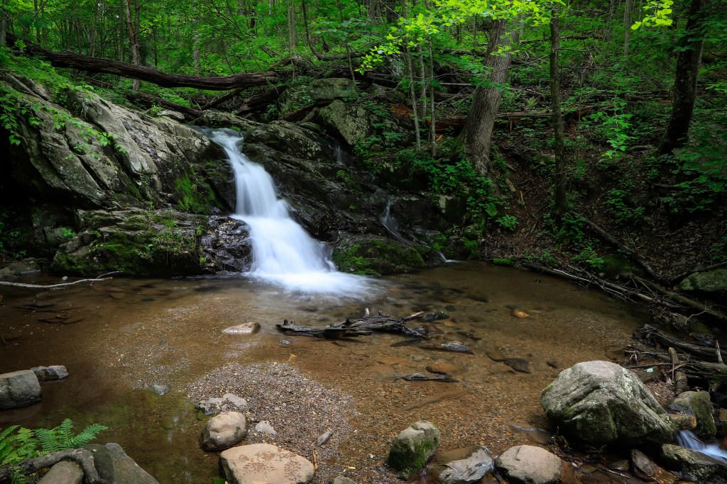
This is the first waterfall I encountered. It was close to the Brown Gap Fire Rd also as Upper Doyles Falls was only 0.3 miles. I wondered at first if this was it, but Upper Doyles was a multi-tiered falls and this was just too small. I really liked this one however, & it has been the screen saver on my iPad ever since this hike.

I really liked the fallen tree across the top. Maybe it was that, maybe it was the rich greens which look best in May to me, or maybe it was my first waterfall of the day. Whatever it was, I really liked it.
Below this was the actual Upper Doyles River Falls. It is listed on the Shenandoah Map at 28 ft. It seemed a little taller to me. There were several groups of people there. I took the side trail to the base but found only an OK view of a partial waterfall filled with people…it was less than prime. What I did find, as the trail climbed out of the gorge, was an optimal view from above the falls, making this one an instant favorite.


I couldn’t get a photo of the waterfall without the hikers at the bottom, and I didn’t feel like waiting because I still had so much left to see and hike. I did really like how the vertical photo really showed all 3 drops here with the beautiful spring green framing it perfectly.

Lower Doyles River Falls is just downstream from Upper Falls, not immediate, but maybe 0.1 miles. This is the trickiest part of the entire hike as the trail descends at its steepest and some wet rocks came into play. No need to try to find a way down from above as it may seem at first, just make your way down the main path, once below the base, a side trail works upstream to get a better view.
Lower Doyles River Falls is twice as high as the Upper Falls. It’s listed at 63 feet and is a beautiful site. I tried numerous compositions, found some I liked, but nothing that topped the vertical Upper Falls comp.


From here, it was a good ways still down stream along the Doyles River Trail, to where the Jones Run Trail meets up. From there I would hike up the Jones Run Trail passing Jones Run Falls, then continuing up until it reached the Skyline Drive and Appalachian Trail. Before I would reach the Jones Run Trail, the Doyles River Trail and Shenandoah still had some nice surprises for me in the form of additional unnamed waterfalls….


This was the first waterfall below Lower Doyles. It has no name, but I would call it “Bent Tree Falls” for obvious reasons. It makes the photo….to me anyway.

The next waterfall was not on Doyles River, but a small tributary, coming down the mountain. This may be one that dries up to nearly nothing in summer, but it looked good on this day.

The last waterfall I photographed before meeting up with Jones Run, was also the tallest unnamed one that I would see, It was probably 20-25 ft and very pretty to look at through the trees. There was no way down to it, but I could have if I really wanted to. I did work my way through the weeds and downfall to about halfway down to get as clear & unobstructed photo that I could. It’s worthy of at least a trail halfway down and maybe a viewing deck. There were other falls as well that I chose not to leave the trail for…..various reasons including the length down vs the size of the falls. Also I still had the main climb ahead and was beginning to think about that.
The Jones Run Trail was fairly long, starting out rather flat, and becoming quite steep for an official trail towards the top. By this point, it was getting later in the day, fog and drizzle were beginning to move in, so I did less exploring of the stream. Jones Run Falls was a quite nice though.


Jones Run Falls is listed at 42 feet, and seems about right. There is a large island in the creek to take different photos of and is a good place to spend some time. The trail cuts back sharply to the left, to some switchbacks up the ridge. The trail pretty much hugs the river right side of the stream and gains steepness as it makes its way back to the Skyline Drive especially after crossing the creek further up. I met a couple at Jones Run Falls and we pretty much made the ascent back up together. They were from Pennsylvania and were nice enough to offer me a quick ride at the Skyline Drive 1 mile up the road back to the Brown Gap Fire Rd. It would have been 1.3 more miles hiking the AT, which runs just below the Skyline Drive along here. I was thankful to them and enjoyed the hike back up with them. Thanks to them, by the time I would have made it to my car, I was actually back in the town of Harrisonburg enjoying a nice beverage..lol
So, in summary, this appears to be a somewhat popular loop hike. If I were to go back and do it again, I believe that I would park at the Jones Run Falls parking area at mile marker 82, take that way down, work up the shorter section of the Doyles River Trail, then a nicer, less steep Brown Gap Fire Rd for the way out, and finally take the 1.3 mile AT or 1.0 mile Skyline Drive back. Either way, it was a great hike, with a lot of good stuff to see. Later, I learned that I missed some nice historical cabins and things by not parking at the actual Doyles River Parking area….maybe some other time.