

Grandfather Mountain was the site this past August weekend for the most rugged, craziest hike I have completed to date. I have been on some hikes that had steep inclines/declines. I have been on hikes that required ladders to climb large boulders. I have even hiked to Calloway Peak, the highest point on Grandfather Mountain via the “Profile Trail”. So…when I saw the warning signs in the parking lot at the famous “Mile High Swinging Bridge”, I just kind of shrugged my shoulders and thought to myself, ” it can’t be that bad….they are just posting this for disclaimers”. Little did I know…….

I have been to Grandfather Mountain numerous times in my life. I even have a season pass there. It is after all North Carolina’s top attraction. The swinging bridge at 5200 ft, and the view that awaits on the other side are both absolute must sees. Just a short ways down the mountain are a number of other places to visit including a museum, fudge/ice cream shop, and a large outdoor wildlife center that allows visitors to get fairly up close for good views of black bears, cougars, eagles, river otters, and deer.


Also, though not officially on display was the largest collection of chipmunks I have ever seen. There had to be at least 30 of them running around on the back side of a building.


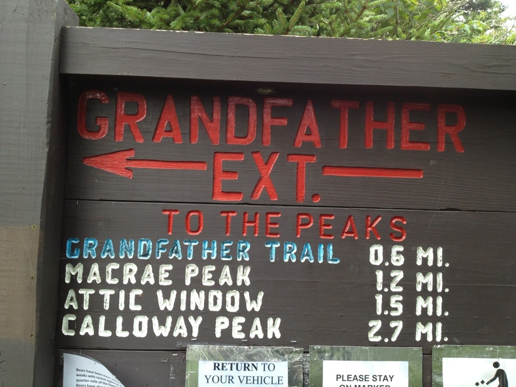
After the wildlife viewing, it was time to get down to business. There was this trail called the Grandfather Trail that needed my attention. This is where the fun truly begins. My hike begins in the Black Rock Parking Lot, the one below the one at the bridge. This is where they want all hikers to park. The red blazed Grandfather Ext. Trail begins here and connects with the Grandfather Trail in 0.6 miles. We had massive storms the day and evening prior and the ditches, and creeks were all flowing well along with just about every rock surface wet. This should have been a sign for me. When I fell and busted my tail on the grass before the trailhead, that should have been a sign. I hiked on. The ext. trail was nothing more than a connector trail, that was a creek the entire way on this day.


The shots above show the condition of the Ext. Trail on this day. It literally was a creek, not a tiny spring or two. This mountain just has a lot of water to drain I guess. It is the starting place for the Linville River, Watauga River, and Wilson Creek just name a few. Notice the fresh deer tracks along the trail, not an uncommon sight up here, they truly are everywhere.
Now that we have made it to the The Grandfather Trail, we are roughly halfway there. 0.6 down, 0.6 to go. The trail from this junction, begins out being rocky, wet and rocky this day. Shortly, Macrae peak becomes visible and fun is sure to be in the near future. The path opens up at Grandfather Gap with lots of huge boulders dotting the landscape. After this, the incline begins.


Cables, thick steel cables are the first assist you will find as the climb goes up over large slippery boulders. There is a narrow pass between 2 huge rocks that has cables and a ladder. From here the trail literally goes straight up!! There is no other way to put it. There will be at least 5 or 6 more ladders to climb, with dicey rocks to navigate between them. As you approach 6000 feet in elevation the wind is a big factor up here. There was also some considerable fog moving in and out, making this hike quite an experience.


Once you have climbed the triple ladders, or what I call the “Stairway to Heaven”, it keeps going up. The blue dotted trail parallels the cliffs now and the terrain is very rocky. It is not long however before you reach this days destination….Macrae Peak.


Once up on this last rock, I savored this moment. This was an accomplishment, not your ordinary hiking trail. A large group was on top with me all just in amazement of the trail and views. Calloway Peak is a beautiful view from here, but with the wet conditions, I felt it was a good point to head back.


Now comes the moment I was really nervous about , going down. This is where most falls happen, and with the crazy climbs just made, I was somewhat worried about going down. I took my time, 1 step at a time and got down eventually. I took the Grandfather Trail all the way back this time to the upper parking lot and then the 0.4 mile Bridge trail to my car that takes you under the mile high swinging bridge for a neat view and perspective. This was quite a hike, one I will not soon forget.


Incredible terrain and you captured it magnificently! Thank you for “taking me there.”
Thank You very much! I am glad you enjoyed it. It was a very fun hike!